
The Fforestfach History Website
Farms - Penll.eithin
Pen-llwyn-eithin Uchaf[1]
Location: Latitude: 51.642125 , Longitude: -3.987780 or Map Grid Reference: SS6255195574
From the 1945 aerial image it's easier to explain Penwyneiddan[2] farm's position. The farm was situated between the bend of Corporation Road on the left and the Queensway on the right, during the development of Fforestfach Industrial Estate Swansea. The end of farm possibly came as a compulsory purchase order of the land by Swansea Council. The area was needed for light industry development and job creation after WWII..
The oldest map I have of the area, you can see how the names have changed. |
Early Fforestfach Industrial Estate, showing only a few buildings. |
|
|
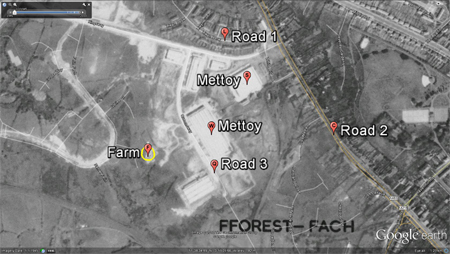 | |
| OS 1805-1874 Map | Google earth 1945 aerial image |
|
| The farm is on the left with Cockett G.W.R. goods yard branch line on the right with the old Greyhound track in-between, latter built off Ystrad Road. | The most recent satellite view. | |
 |
 |
|
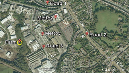
| OS 1940 Cockett Map | Google earth 2009 satellite image |
|
| My reference |
||
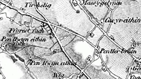
MAPS OS 1805-1879: Pen llwyn eithen[1] is connected to the underlined Carmarthen Road. The farm's is also connected on its north west access to related farm called Pen llwyn eithin fach which had a track leading Ystrad Road near Ystrad uchaf. This related farm name isn’t seen on later maps, as its name changes to Felin-fach.
1843 Tithe Apportionment: Penllwn Ithan[3] ycha Landowner - John Dillwyn Llewelyn Esquire, Occupier - William Williams, Land - 20 areas of land including at least 2 houses, Payable to vicar 15 shillings, Payable to Sir John Morris Baronet £1.10.00. While comparing both Tithe Map and the OS 1805-1879, I found Penllwn Ithan[3] ycha fields were next to Raven Hill farm bottom fields; there is more room for further investigation between the the Tithe map and its relevant Apportionment of 1843.
1879 OS Map 1:25 000 Swansea, St John & Llangyfelach Parishes: Pen-llwyn-eithin-uchaf[1].
1899 OS Map Penderry PH. - Pen-llwyn-eithin[1] Uchaf.
1916 OS Map Penderry PH. - Pen-llwyn-eithin[1] Uchaf.
1940 OS Map – Pen-llwyn-eithin[1] Uchaf. GWR railway line, timber Yard connected to mainline railway at Cockett, where brick works used to be.
1950-55 OS Map - no name.
1964 OS Map - no name. The GWR railway junction at Cwmbach Cockett with a mill described at centre of this junction.
POLLING DETAILS: (1845) Page 81, Parish of Swansea Higher.
(1869) (a) Swansea Polling District, The Hamlet of Swansea Higher.
(1869) (b) Swansea Polling District, The Hamlet of Swansea Higher.
DIRECTORIES: 1895 Kelly's Directory, page 750 Williams Llewellyn, farmer, Penllwyneithen[1]
1914 Kelly's Directory, page 965
Census 1851 - Land 72 acres ________________________________________________________________________________________________
In 1871 William was still living at home age 24 - could he possibly have been given or rented some farmland nearby? By 1881 Llewelyn (the younger) was the only child still living at home. In 1901 Llewelyn was named as an 'employer' By 1901 Mary Williams was living at Nyddan Villa so the farm must have left the family between 1901 and 1911.
In some census returns Llewelyn is written Lewlyn.
I am the great granddaughter of Llewelyn and Mary Williams.
Extract written by Eleanor Price ________________________________________________________________________________________________
REFERENCE: [1]The word Pen-llwyn-eithin is spelt a number of ways on this page, all taken from orginal print. Penwyneiddan[2], Penllwn Ithan[3] ,Penllwynerthan[4]. Maps - West Glamorgan Archive Service and Swansea library and http://www.old-maps.co.uk/maps.html. Kelly's Directories - West Glamorgan Archive Service and Swansea library Polling Directories - Swansea library Thank you to Eleanor Price for her research and helping building a history of Pen-llwyn-eithin Uchaf
|
______________________________________________________________________________________________
Thank you Mr. Nigel Alan Robins |
Thank you to the City & County of Swansea for all your help and support. |