
The Fforestfach History Website
Farms - Gendros
Gendros
Location: Latitude: 51.641086 , Longitude: -3.972574 or Map Grid Reference: SS63609543
The building where Gendros is alongside is two thirds of the way, what is now Upper Kingshead Road. Gendros Farm's position in the red ring. |
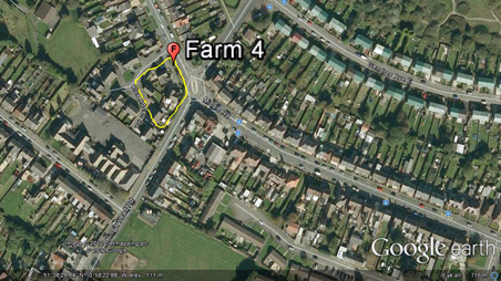
The farm has several buildings in the this view. The newly built homes of Gendros Avenuse East in the upper right of the image. |
|
|
 | |
| Gendros OS 1805-1874 Map | Google earth 1945 aerial image |
|
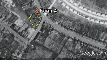
Genros Farm behind Gendros School. There are roughly seven building on the farm. |
Gendros a built up residential area. | |
 |
 |
|
| Gendros Farm OS 1940 Map | Google earth 2009 satellite image |
|
L.B.= Letter Box = = = = - Pavement or Path | ||
| 4* - The number relates to my own research. |
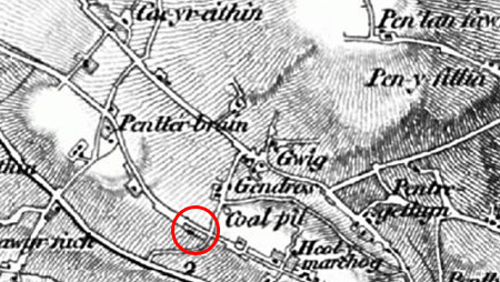
MAPS 1805-1879 OS: Gendros farm, showing 1 building joined to only one access which was Middle Road, no Kings head Road or Upper Kings head Road. A place called Gendros with 2 buildings opposite is on a road linking Pentregethin Road and Middle Road; it looks like Weig Road later joins this now lost road to Carmarthen Road.
1838 Tithe Apportionment[1]: Genros[2] Land Owner - Sir John Morris, Land Occupier - Joseph Griffiths, Land - 9 parts could be 10 with at least 22 acres.
1879 OS Map Swansea, St John & Llangyfelach Parishes 1:25 000 The farm isn't labeled but has a single building labeled as (671,.563) and a number of trees around the property, nearest building in area (678) across the road, where a small semi’s are next but one right to Martin’s corner shop today (2013).
1899 OS Map Penderry PH. 1:2,500 The farm (Land No. 227), (Area size .563) is labeled diagonally right of the property (Land 229, Area size 5.446), today this would be, right of Upper King's Head Road, roughly 500 feet square and possibly used by the farm. The farm has 4 building in total, 3 joined and 1 close to the Middle Road boundary. No Gendros School, yet. Middle Road is labeled. King's Head Road is labeled.
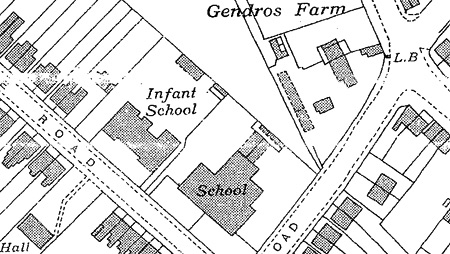
1916 OS Map Penderry PH. 1:2,500 The farm (Land No. 227), (Area size .563) is labeled diagonally right of the property (Land No. 229, Area size 5.446), today this would be, right of Upper King's Head Road, roughly 500 feet square and probably used by the farm. The farm has roughly 6 buildings. Gendros School, infants and juniors are now built along most of the current building (2013) on Armine Road. Outside the farm on the corner of King's Head and Middle Road there is a W.T.= Water Tap.
1940 OS Map Swansea Co. Boro. Swansea PH. 1:2,500. Gendros Farm is labeled next to the buildings; there are no numbered labels as above. The farm has roughly 8 buildings, but now has less land to work as diagonally right is a full row of houses on Middle Road as it is today 2013. No reference to a water tap, but roughly where this is now a L.B.= Letter Box..
1948-50 OS Map Glamorganshire 1:2,500 Gendros Farm is labeled next to the buildings. The farm now has roughly 10 buildings. As Gendros Avenue East and West housing has been built, Upper King's Head Road is now built and labeled. Martin's corner shop has now been built, Henry Martin took on the shop in the late 1940s. L.B.= Letter Box is still labeled. El P= Electricity Pole or Pillar on the corner of current Martin's corner shop Middle Road (2013). r.p.= reference point outside current Martin's corner shop Middle Road (2013).
1968-1971 OS Map Brecknockshire 1:2,500 The farm has now been demolished.
POLLING DETAILS: 1845 Page 81, Parish of Swansea Higher. Voters in respect of Property, including Tenant Occupiers at a Rent of £50 and upwards.
1869 (a) Swansea Polling District, The Hamlet of Swansea Higher. Nature of Qualification: freehold lease of house, Details: Part of Gendross[3]
DIRECTORIES: 1923 Kellys directory South Wales, page 979 Mrs. Elizabeth Jeffreys, farmer Gendros farm.
1923 Kellys directory of Monmouthshire and South Wales, page1024 Mrs. Elizabeth Jeffreys, farmer Gendros farm.
1926 Kellys directory of Monmouthshire and South Wales, page1024 Mrs. Elizabeth Jeffreys, farmer Gendros farm.
BOOK: The Story of Swansea Districts and Villages Volume , Fforestfach, Thomas Norman Lewis, 1969, page 53 "Penllernarch Road (Mari Jacob) I also recollect and the Gendros Farm worked by John and Ann James;"
The Story of Swansea Districts and Villages Volume, Fforestfach, Thomas Norman Lewis, 1969, page 54 "Kelly's detailed directories of South Wales at the turn of the century confirm a number of Mr. J. Davies' recollections. The 1906 edition, for example, refers to Chas Vickery, cowkeeper, Cae-y-Babell; Thomas Passmore, farmer, Cae-y-Babell; John James, farmer, Gendros farm; and Wm. Williams, farmer, Tyrbach."
BOOKLET: Gendros Primary Centenary, Design by Designprint, City and County of Swansea 1997, page 1 "The land bordering King's Head Road was deemed the most suitable place to build the school. Behind this parcel of land was a farm which in future years was used as an educational resource and in some cases a place of part-time work for a few of the children." Also on the same page is a very interesting drawing of the layout of the farm probably in the early 1940s.
To my knowledge there is only one remaining piece of evidence that Gendros farm was ever on the corner of King's Head and Middle Road. Today 2013, if you walk passed Gendros School towards Middle Road, you will see a low level stone built wall approximately 200ft long and over a foot deep, which was the farm's boundary wall.
More personal information about Kenny's family history of Gendros farm is written along with photos in this FORUM LINK. ________________________________________________________________________________________________
NOTE: [1]More work to done with 1838 and look at 1843 Tithes. [2]Written this way on 1838 on Tithe Apportionment. [3]Written this way on 1869 Polling Details.
REFERENCE: Maps - West Glamorgan Archive Service and Swansea library and http://www.old-maps.co.uk/maps.html. Kelly's Directories - West Glamorgan Archive Service and Swansea library Polling Directories - Swansea library
|
______________________________________________________________________________________________
|
Thank you to the City & County of Swansea for all your help and support. |